Our students are engaged in several diverse projects that provide highly recognized insights on the nature of petroleum geology, the environment, geomorphology, geophysics, paleontology and sedimentology, and igneous petrology. We foster student involvement in all of our research endeavors. Most of our classes incorporate our research findings, exposing all of our students to research. Furthermore, we support a number of undergraduate researchers who are directly responsible for pursuing significant results. We are now seeking qualified and motivated graduate researchers to tackle a number of independent avenues within our research expertise.
Petroleum Geology | Geophysics | Hydrogeology and Environmental Geology
Petrology and Geochemistry
Our faculty participate in UGROW and EURECA during the summer and academic year, respectively. These are interdisciplinary research programs that provide monetary and infrastructural support to undergraduates. We are also active in advising student research through independent study (GEOS 491X) courses.
Students may also embark on research with the Texas Stream Team at Midwestern State University, a network of certified students and professionals dedicated to protecting and promoting environmental stewardship of the Wichita Falls waterways.
The Robert L. Bolin Graduate School of Geology requires students to complete an original research project and thesis in one of the above areas of concentration. Prospective graduate students will seek out an area of concentration as part of the application process. Under faculty guidance, graduate researchers will engage in a well-defined topic that provides unique and novel insight, potentially leading to publication in the scientific literature.
Dr. Meddaugh’s current research interests are focused on several aspects of petroleum geology and reservoir characterization including:
- Impact of geostatistics, reservoir modeling, heterogeneity, uncertainty, and human bias on reservoir performance forecasts, particularly for conventional oil and gas reservoirs and also on unconventional shale gas and shale oil.
- Efficient incorporation of uncertainty in reservoir modeling, performance forecasting, and reservoir development decisions.
- Interaction of reservoir rock and fluid with injected steam – impact of continuous injection and single vs. multiple cycle, cyclic steam stimulation (CSS) in non-clastic reservoirs. Application of reactive transport modeling (RTM) to understand the mineralogical and fluid changes induced by the injected steam as well as the impact steam injection on porosity and permeability.
- Improved methods of accounting for historical production data uncertainty (e.g. allocation factors, low frequency well tests, “missing” data particularly for mature fields) particularly as it impacts decline curve-based assessments and dynamic model history matching.
- Application of chemostratigraphy (core-based or cuttings-based) and stable isotopes as a reservoir characterization tool for carbonate reservoirs and for possible use as “sweet-spot” predictor (productivity and/or fracture susceptibility) for unconventional shale gas and shale oil plays.
- Appropriate scale for characterization of permeability used in geostatistical reservoir models; particularly carbonate reservoirs where large permeability multipliers are typically needed during history matching.
More details: Dr. Meddaugh's ResearchGate Page
Key Research Facility: The Robert L. Bolin Petroleum Geology Laboratory
Dr. Katumwehe's research is in two principal areas of tectonophysics and near surface geophysics based on problems, spanning the very shallow subsurface to deeper crustal-scale. He is engaged in examining the geodynamic evolution of active and inactive continental rifts.
Mineral exploration: The integration of geophysical data such as magnetics, radiometrics, gravity, induced polarization, seismic and time-domain electromagnetic data for resource evaluation.
Engineering and archeological geophysics: Geotechnical investigations based on non-destructive testing of infrastructure based on the use of seismic, microgravity, electric and GPR data. The work highlights the importance of geophysical detection of underground utilities, voids, cavities and tunnels, dam safety as well as evaluation of seismic hazards.
Archaeological exploration: Acquisition and analysis of 3D geophysical data (GPR and resistivity) to produce high quality images of buried antiquities. This non-invasive tool preserves these sites from environmental and cultural hazards.
Hydro-geophysics: Mapping and characterizing groundwater aquifer systems and contaminants based on geo-electrical measurements, influenced mainly by pore-fluid. Evaluating the geothermal economic potential by integrating gravity, time-domain EM, magnetics, micro seismicity and magneto-telluric data.
Oil and gas: Evaluating the thermal maturity of oil and gas reservoirs in rift system and other frontier basins by using the unconventional method of hydrocarbon basin analysis by integrating potential field geophysical methods (gravity and magnetics) and basin modelling approach to determine crustal thickness a proxy for heat flow and source rock maturation.
Environmental and agro-geophysics: Mapping leachate plumes from contaminated former landfill sites and mapping UXO’S. Evaluating the radio isotopes (potassium, thorium and uranium) as key indicators in soil productivity.
- Tectonics: Evaluating how extensional strain is localized and subsequent rift segmentation during rift initiation, rift propagation, segmentation and termination.
- Thermal structure and crustal thickness beneath the Albertine Graben: Observations from airborne, satellite gravity and borehole data.
- The role of pre-existing lithospheric scale fabric in continental rifts: Integrating airborne gravity data, magnetic and satellite gravity data to assess rift evolution.
- Petroleum basin evaluation: Understanding basin architecture, thermal anomalies and petroleum systems based on the un-conventional methods for hydrocarbon basin analysis by integrating potential field geophysical methods (gravity and magnetics), sedimentary stratigraphy and basin modelling approach to determine heat flow which potentially serve as a proxy indicator of source rock maturation within continental rift basins.
- Lithospheric structure characterization: Assessing the crust beneath the Mesozoic Chilwa Alkaline Province in Southern Malawi and Northeastern Mozambique based on using airborne magnetic data and satellite gravity.
- Void detection: Finding low-density cavities using a combined VP, VS and Electrical Resistivity a contribution to application of Geophysics to Engineering and Environmental Problems.
Dr. Mahmud is a modeler and remote sensing expert with both hydrogeology and terrestrial carbon cycle background. He applies a diversity of approaches for the characterization of complex geological and environmental systems. He is interested to offer a diverse pallet of geoscience and environmental science projects to students. Below are few ongoing and potential future projects in his lab:
- Dr. Mahmud is working to produce large-scale hydrogeological properties through numerical modeling and remote sensing. Using image-based modeling, the project forms a novel framework to generate a larger synthetic cave system which may allow the scientists to investigate various hydrogeological properties in an advanced larger scale. The project aims to provide more accurate identification of large-scale subsurface flow variability, both spatially and temporally.
- Dr. Mahmud utilizes LiDAR remote-sensing data to better estimate forest biomass and carbon storage. He uses recently developed tools to process forest LiDAR data for segmentation and geometric modeling. These tools provide automatic quantification of forest biomass. The project aims to identify the best possible available tool for accurate biomass estimation, providing unique information about forest structure and management practices.
- In a current project with collaborators from Indiana University, Dr. Mahmud is performing geospatial modeling using both satellite and airborne data to understand topographic and environmental drivers of vegetation distribution in dryland ecosystems.
- Dr. Mahmud is working to understand the response of the carbon cycle and terrestrial ecosystems to climate and environmental changes. He employs data assimilation (DA) methods to constrain global carbon cycle sink projections and modeled carbon-climate feedback. He relies on a wide array of observations to test, develop and constrain terrestrial biosphere models that form the land component of Earth system models.
- Dr. Mahmud developed a novel DA tool with colleagues from the Hawkesbury Institute for the Environment at Western Sydney University. The effort brings together modeling and data to understand the underlying mechanisms impacting plant growth under various climate change conditions. He is now working in two separate projects applying the DA technique to other manipulative experiments, to infer the effects of temperature warming and drought on plant carbon balance processes.
- Dr. Mahmud is interested in utilizing Unmanned Aircraft System (UAS) remote sensing to map earth surface features to characterize its properties, or understand the changes in ecosystems, hydrology, forestry, and so on. He tries to target the dynamics of Earth systems undergoing unexpected disturbances or gradual changes. Examples: he is interested in investigating cave sites around Texas and in mapping the forest canopy to understand its dynamics and eventually improve prediction of carbon cycle.
- Dr. Mahmud is looking to utilize LiDAR surveys to various other cave projects: such as to map the extent of cave damage by touristic exploitation, perform assessment and environmental management of tourist caves using recurrent LiDAR surveys. Repetitive LiDAR measurements could also be used to measure speleothem growth rates in environments where this growth is extremely fast.
- He is interested expanding the use of cave-drip looger data. These measurements could further constrain the water balance in hydrological models by combining a logger network with surface weather station and soil moisture network. Moreover, combining drip loggers with surface geophysics data could track water movement in karst aquifers.
- Remote sensing provides a means of observing hydrological state variables over large areas. Examples include determining land-surface temperature from thermal infrared data, surface soil moisture from passive microwave data, snow cover using both visible and microwave data, water quality using visible and near-infrared data, and estimating landscape surface roughness using LiDAR. Novel techniques need to be developed and improved for estimating the hydrometeorlogical fluxes, evapotranspiration, and snowmelt runoff through these state variables.
- Dr. Mahmud is also interested in solving various challenges in remote sensing data by applying stochastic image analysis and geostatistical methods. Despite having large coverage and degree of detail, the remote-sensing data can be of insufficient quality or resolution for many applications. Challenges include the filling of gaps and fusing data across scales. He has particularly worked on geostatistical methods based on training images which he plans to exploit to improve remote sensing data quality.
- Another direction would study vegetation-environmental change feedbacks utilizing a wide range of remote sensing and in-situ data streams to ensure these processes are adequately represented in terrestrial biosphere models, improving predictions of the global carbon sink.
- Dr. Mahmud is very enthusiastic to see his novel DA approach applied to other plant manipulative experiments to untangle the impacts of all physiological and biochemical processes on plant growth due to various environmental changes. This should help to understand how forest ecosystems respond to climate change and human activates.
More details: Dr. Mahmud's Webpage; Dr. Mahmud's Google Scholar Page; Dr. Mahmud's ResearchGate Page
Key Research Facility: Remote Sensing and Modeling Lab
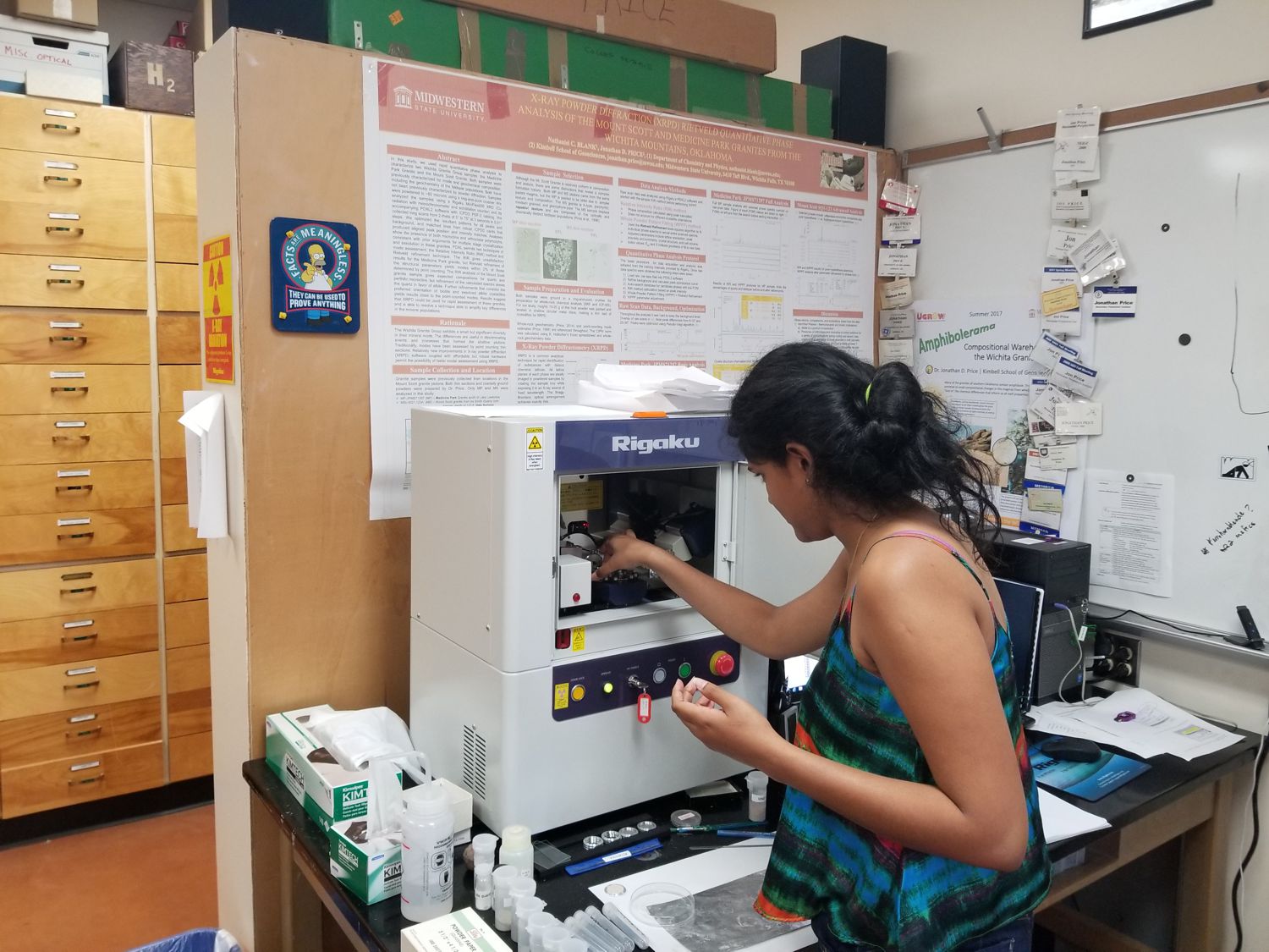
Dr. Price’s research focuses on the origin and nature of rocks (petrology) and the chemical systems from which they originate. He’s interested in magmatic materials and processes associated with volcanoes and their subterranean counterparts, plutons. His most recent projects utilize field exploration and mapping, geochemical analysis, and computer modeling to evaluate the crystalline rocks of southern Oklahoma, including the Wichita Mountains, the volcanic materials of the Trans-Pecos, west Texas, and the relatively young volcanoes of central Oregon. In addition to magmatism, Dr. Price is also interested in mineral growth and geochemistry in a variety of geologic settings.
- Evaluation of granitoids and associate rocks in southern Oklahoma. The Wichita Mountains, located within an hour's drive north of MSU, preserve the products of Eocambrian rifting. This natural lab provides tremendous insight to magma genesis, evolution, and emplacement process.
- The interactions of volcanism and tectonics in and around the Dalquest Desert Research Station, Big Bend, Texas. MSU's westernmost part of campus contains stunning of examples of Eocene and Oligocene igneous activity and key elements of the transition into Basin and Range activity.
- Silicic volcanism in the central Oregon Cascades. The arc systems of the region exhibit numerous complexities regarding igneous sources and their evolution.
- Assessing crystallization pathways through igneous microstructure. Granitoids and other igneous rocks exhibit a range of textures that arise from variations in geochemistry and external conditions. Microstructure and morphology can provide details about crystallization.
More details: Dr. Price's ResearchGate Page Dr. Price's Google Scholar Page Dr. Price's Webpage
Key Research Facility: Petrology and Geochemistry Lab